This time, Vincent’s suggestion was that we follow the recently-inaugurated Ligne Grande Vitesse (LGV) railway line from Bordeaux to wherever we would be when we finally decided to turn back. We didn’t expect to see very much of note but decided to proceed nevertheless in case we were wrong. It actually turned out that, on the whole, we had been right, but we did gain a better understanding of the railway line’s course, and did make precisely one interesting discovery. What could it possibly have been?
First though, a little background information: this new addition to France’s high-speed railway network has been operational since July 2017, a full 25 years on from the concept being initially green-lighted, and after five years of work on this stretch between Tours and Bordeaux (or, more precisely, between Chambray-les-Tours and Ambarès-et-Lagrave). The end-result of the mammoth 7.8-billion-euro engineering project led by contractors Vinci is a brand new line enabling non-stop high-speed rail travel between Bordeaux and Paris, cutting travel time between the two cities to just a little over two hours.
 |
| Saint-Jean station as viewed from the new multi-storey car park. |
Symbolically enough, Vincent and I meet up at Saint-Jean railway station and, to enjoy a panoramic view of the city’s rail transport hub, head to the top of the brand new multi-storey car park. The car park has been built as part of the wider redevelopment scheme on the Belcier-facing southern flank of the station, in line with the creation of the new “Euratlantique” residential and business quarter. The station entrance has also been completely overhauled, with the addition of shops, takeaway outlets and a restaurant. At one of the outlets Vincent goes looking for a chocolatine (for Parisian readers, that’s a pain au chocolat) but gives up after an ugly queue-jumping incident. At another he is informed he will have to wait ten minutes. We decide to make a move instead.
We set off and aim for
Pont Saint-Jean, Bordeaux’s great unloved bridge, crossing the Garonne river a few metres away from the railway bridge. We drive through the Bastide quarter and past the high-rise buildings of the
Cité de la Benauge, which rarely make it onto postcards but are the first sight that railway travellers enjoy of Bordeaux. We proceed north and make a first stop in Lormont, which estate agents reportedly refer to as “the Montmartre of Bordeaux”. We spot a first TGV racing into the tunnel there and Vincent suddenly feels sorry for the people on board whose telephone conversations have been unexpectedly cut short. A security gate preventing access to the line is conspicuously unlocked, and over the warning message the words “From Paris with love” have been artfully graffitied. We take in the view of the
Pont d’Aquitaine and move on towards Bassens.
 |
| "From Paris with love" in Lormont. |
In Bassens, we head towards the station in the vague hope that Vincent will finally get his hands on a chocolatine. Moving inland from the waterfront docks and industrial warehouses, it turns out the station is located in a residential district. We head onto the platforms to get a feel for the place but it is a quiet, lonely experience. We do however get to cross the railway lines on foot in search of a slightly dangerous photo opportunity. Once the photo has been taken, Vincent informs me that photos of the like are prohibited. Oh well, too late. We move on to Bassens town centre, perched up on high, and fail once again in our quest to find a chocolatine, although there are plenty of hairdressing options.
 |
| Kids, don't try this at home. |
Our next stop is the wonderfully-named La Gorp railway station in Ambarès-et-Lagrave which, you may remember, is where the new line technically starts. The roadbridge over the lines and station is pleasingly modern. On either side, big stainless steel panels are broken up by windows that have been designed with trainspotters in mind. As if on cue, another TGV steams past northwards; after holding back in the vicinity of Bordeaux, the train is about to hit full throttle and reach its cruising speed of 300 to 320 kilometres per hour.
 |
| Windows on the railway lines. |
Departing Ambarès, Vincent excitedly spots a roadside boulangerie and heads inside as part of his ongoing mission to get his hands on a chocolatine. They’re out of chocolatines though so he has to make do with a cookie. Who would have thought that such a simple request would be so challenging? Somewhere between Saint-Vincent-de-Paul and Saint-Loubès, we hit the Dordogne, admiring the bridge over the river which was built to accommodate the new line. We spot a house at its base which appears to have been abandoned. Were the owners forcibly moved on?
 |
| 1,319 metres long, 45,000 cubic metres of cement, 150,000 tons: it's the LGV bridge over the Dordogne. |
We opt for the simplest means of crossing the Dordogne: a short stretch of the A10 motorway, exiting as soon as we can to continue following the railway line. From now on, this exercise becomes a complicated case of slaloming back and forth over the line; it’s virtually impossible to drive alongside in perfect linear fashion. We eventually reach a railway station which has been given the name of its two neighbouring villages: Aubie-Saint-Antoine. The station is only served by the longstanding Bordeaux-Nantes line, the LGV trains do not stop here. But its presence is tangible given the brand new car park and a modern red metallic footbridge over the lines; the station has clearly benefited from the arrival of the LGV.
 |
| Vincent inspecting the modern footbridge at Aubie-Saint-Antoine station. |
 |
| Looking over towards Saint-Antoine. |
On the next stretch of our drive towards Marsas and the point where the Nantes line and the LGV split for good, beneath yet another new bridge we spot what used to be the entrance to a level crossing across the old railway tracks. A white cross has been erected there, a sad reminder of how deadly level crossings have so often proved to be (and as was once again the case recently in Millas, near Perpignan). There are no inscriptions on the cross, just some faded artificial flowers; we move on not knowing the full story of what once happened there.

We carry on north to Laruscade, a small market town which is stuck in that limbo zone where it has neither the charm of a tiny village nor the amenities of a larger town. On its outskirts, where a surprisingly high number of properties are up for sale, many of the single-storey houses are of a Mediterranean-style yellow colour – this annoys Vincent profusely, who remains agitated and only really calms down when he spots the sign welcoming us to Charente-Maritime. Geographical landmarks of the like get him quite excited, so it’s quite a big deal when we alight to take a photo immortalizing our crossing the departmental border line.

We then loop up towards Bedenac, a small town which is possibly best-known for its prison. One of the distinguishing features of the establishment, Google suggests, is that the inmates are given sessions of what is termed “
médiation canine”. Further information is available
here. Moving off the beaten track to the west of Clérac, we go in search of a sight of what is labelled on Googlemaps as “
la Base de maintenance de Clérac”. Although the satellite view is impressive, from our vantage point on the other side of the tracks, there is really not much to be seen at all.
 |
| Looking over towards the Base de maintenance de Clérac. Wow. |
We drive on to Clérac proper and treat ourselves to lunch in a small hotel-restaurant establishment,
l’Auberge des Lacs Bleus. After our meal we take some time out to visit the town centre, which is all very neat and tidy and pretty; Clérac was one of the technical hubs of the LGV project and the economic benefits were substantial throughout the construction period. Much of this has no doubt been translated into embellishing the environment here. We nip into the church, walking beneath a sundial which is a good deal smaller than its associated information panel. Vincent spots an old “CITRAM” bus stop and we have visions of travellers getting on buses here to journey to far-off climes.
 |
| The sundial and the CITRAM stop, Clérac. |
Given the lack of excitement so far (with the possible exception of Vincent’s chocolatine quest), we decide our next stop, Montguyon, will be the northern tip of our journey. We admire the town and the ruins of its medieval castle from a distance and drive towards the impressive 135-metre-long structure bridging the gap between the hills either side of Montguyon for the LGV. When parking the car we bump into a genuine trainspotter – well, not a full-on trainspotter who is up on train types and numbers, but rather a local who knows that trains pass by regularly and who just gets a kick out of seeing them. There is much celebrating when a TGV ploughs past at top speed.
 |
| Montguyon railway bridge. |
We are now more or less 70 kilometres from our starting point and it’s not yet mid-afternoon, so Vincent and I decide to backtrack to an unusual sight we had spotted on our outbound journey: somewhere around Cavignac, just to the south of Laruscade, we had driven over a disused railway track. We return to the spot to find out more and to see whether the old line and the LGV intersect at some point.
We park by a house next to what remains of a level crossing, and get chatting to the person who lives there – he had purchased the house, where he was born in 1957, from his grandmother who had been in charge of the level crossing on the railway line when it was still in operation. Although the information he provided was sketchy at best (and the clarity of the data he delivered was possibly affected by that day’s early aperitif), we later established
the line had connected Cavignac with Coutras. It had operated passenger services from 1874 until 1938 and freight trains continued to run here until the mid-1960s. The line closed for good in 1976 although
a tourist steam train now runs on a section further east between Marcenais and Guitres.
 |
| The old level crossing and house. |
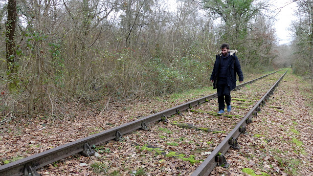 |
| Vincent making his way along the disused railway line. |
Checking his phone, Vincent estimates the distance between the old level crossing and the new LGV line to be around 600 metres, so we set out on foot along the moss-covered tracks towards the inevitable dead end. We soon arrive at our destination and view a couple of high-speed trains whizzing past this point where a previous-generation railway line has come to an abrupt end. It all feels suitably symbolic – we are left wondering whether at some stage in the future the LGV tracks will meet a similar fate.
 |
| The end of the line, where old meets new. |
We turn round and head back towards the car, wondering what we’ve learnt from our day tracking the LGV tracks. We agree that we now have a clearer idea of how the project has made an indelible stamp on the landscape and the impact it has had, for better or for worse, on the towns and villages that lay alongside the line. And, above all, we now realise that north of Bordeaux it is easier to get a haircut than a fresh chocolatine.
We head onto the southbound Nationale 10 road, soon joining up with the heavy motorway traffic heading, like us, into Bordeaux. The loneliness of the deserted abandoned railway line in Cavignac suddenly feels a long, long way away. But to Vincent and myself it now feels strangely comforting to know it is there, silently observing LGV trains en route to and from Bordeaux and Paris. With love.
This adventure is also available as a major motion picture!
> Find the old Cavignac-Coutras railway line on the Invisible Bordeaux map: disused section of Cavignac-Coutras railway line, Cavignac.


Follow/contact